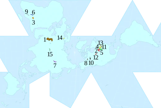
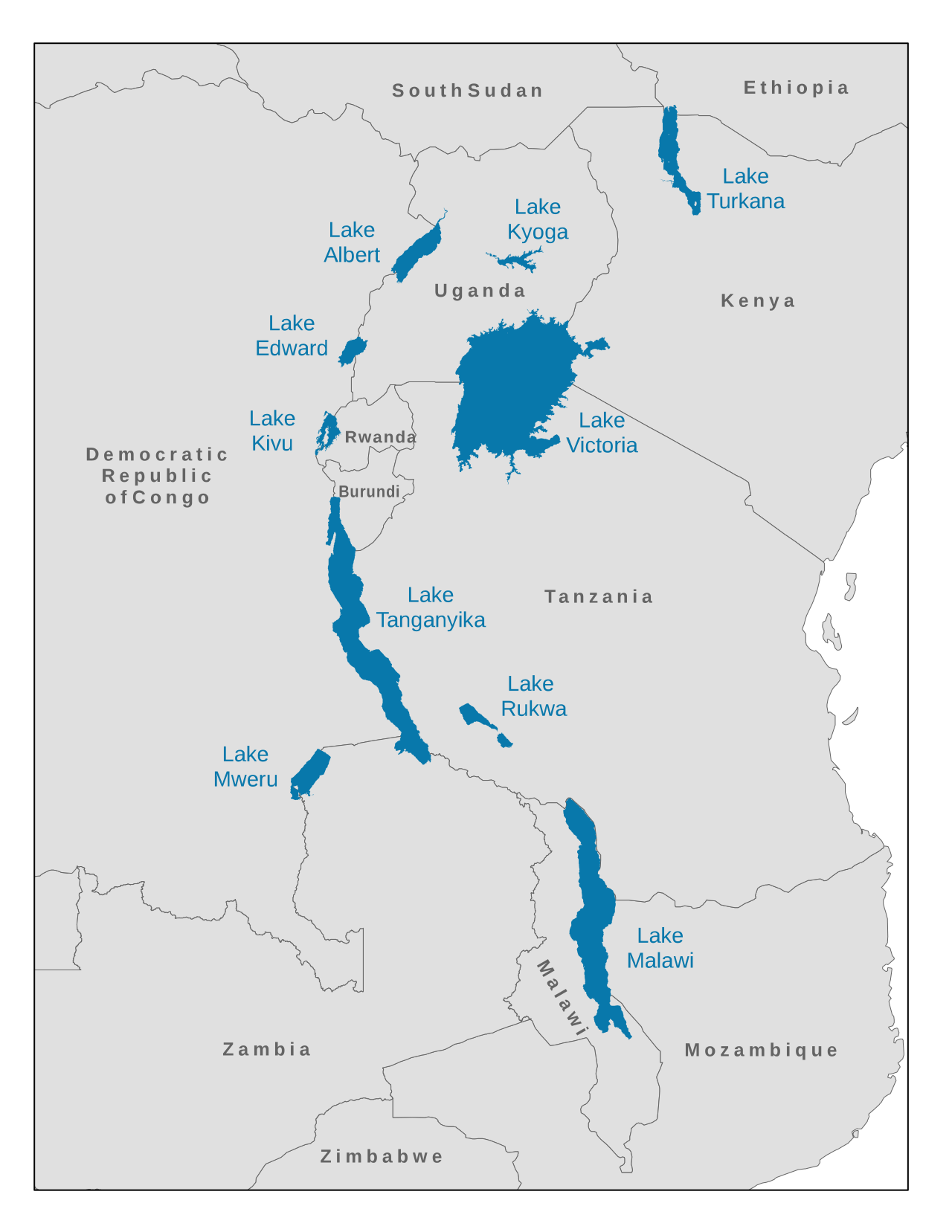
Lake Mweru
A rift valley lake on the Congo River border.

NASA · Public domain
Lake Mweru (also spelled Mwelu, Mwero) (French: Lac Moero, Swahili: Ziwa Mweru) is a freshwater lake on the longest arm of Africa's second-longest river, the Congo. Located on the border between Zambia and Democratic Republic of the Congo, it makes up 110 kilometres (68 mi) of the total length of the Congo, lying between its Luapula River (upstream) and Luvua River (downstream) segments. Mweru means 'lake' in a number of Bantu languages, so it is often referred to as just 'Mweru'.
- Location
- Border of Zambia and Democratic Republic of the Congo
- Length
- 118 km (average)
- Width
- 45 km (average)
- Elevation
- 917 m
- Maximum depth
- 27 m
- Primary inflow
- Luapula River
- Primary outflow
- Luvua River
Verified Timeline
Lore & Background
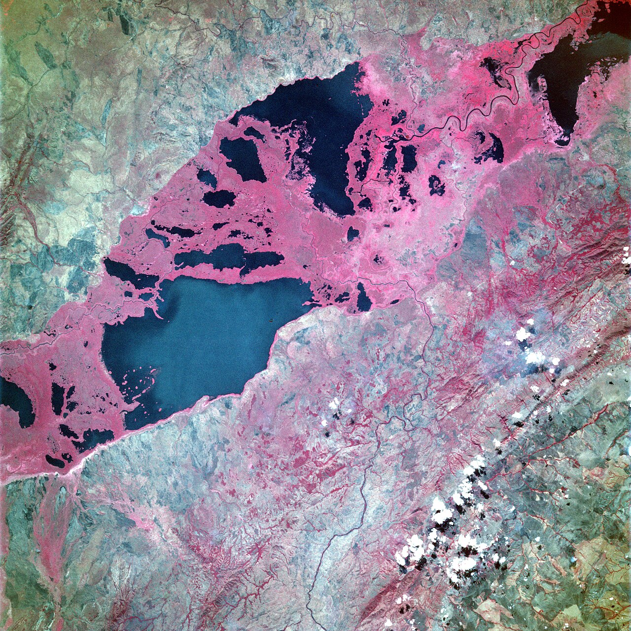
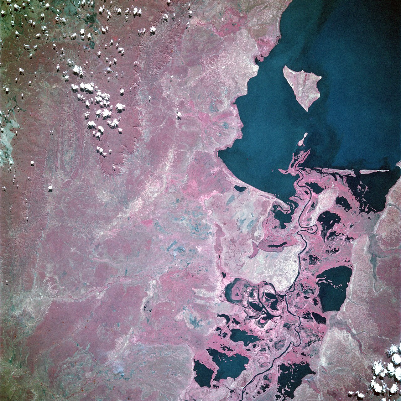
Mweru is mainly fed by the Luapula River, which comes in through swamps from the south, and the Kalungwishi River from the east. At its north end the lake is drained by the Luvua River, which flows in a northwesterly direction to join the Lualaba River and then to the Congo. It is the second-largest lake in the Congo's drainage basin and is located 150 kilometres (93 mi) west of the southern end of the largest, Lake Tanganyika. The Luapula forms a swampy delta almost as wide as the southern end of the lake. For a lake in a region with pronounced wet and dry seasons, Mweru does not change much in level and area. The annual fluctuation in level is 1.7 metres (5 ft 7 in), with seasonal highs in May and lows in January. This is partly because the Luapula drains out of the Bangweulu Swamps and floodplain which tend to regulate the water flow, absorbing the annual flood and releasing it slowly, and partly because Mweru's outlet, the Luvua, drops quickly and flows swiftly, without vegetation to block it. A rise in Mweru is quickly offset by a faster flow down the Luvua. Mweru's average length is 118 kilometres (73 mi) and its average width is 45 kilometres (28 mi), with its long axis oriented northeast–southwest. Its elevation is 917 metres (3,009 ft), quite a bit higher than Tanganyika (763 metres (2,503 ft)). It is a rift valley lake lying in the Lake Mweru-Luapula graben, which is a branch of the East African Rift. The western shore of the lake in DR Congo exhibits the steep escarpment typical of a rift valley lake, rising to the Kundelungu Mountains beyond, but the rift valley escarpment is less pronounced on the eastern shore. Mweru is shallow in the south and deeper in the north, with two depressions in the north-eastern section with maximum depths of 20 and 27 metres (66 and 89 ft).
Reader's Guide
The lake was known to Arab and Swahili traders (of ivory, copper and slaves) who used Kilwa Island on the lake as a base at one time. They used trade routes from Zanzibar on the Indian Ocean to Ujiji on Lake Tanganyika to Mweru and then to the Lunda, Luba, Yeke or Kazembe kingdoms, the last being on the southern shores of Mweru. Western trade routes went from those kingdoms to the Atlantic, so Mweru lay on a transcontinental trade route. Explorer and missionary David Livingstone, who referred to it as 'Moero', is credited with its discovery during his travels of 1867-'8. Livingstone witnessed the devastation and suffering caused by the slave trade in the area to the north and east of Mweru, and his accounts did help rally opposition to it. The western shore of Luapula-Mweru became part of the Belgian Congo and the eastern shore part of Northern Rhodesia, a British protectorate. Although Kilwa Island is closer to the western shore, it was allocated to Northern Rhodesia, and consequently Zambia has 58% of the lake waters, and DR Congo 42%. The first Belgian outposts on the lake were set up at Lukonzolwa and Pweto which were at various times the headquarters of their administration of Katanga. The first mission station on the lake was established in 1892 by Scottish missionary Dan Crawford of the Plymouth Brethren at Luanza on the Belgian side of the lake. The Congolese side of the lake was affected by the Second Congo War of 1999–2003, from which it is still recovering. Many refugees entered Zambia at Pweto and were accommodated in camps in Mporokoso and Kawambwa districts.
Did You Know?
- Mweru means 'lake' in a number of Bantu languages, so it is often referred to as just 'Mweru'.
- The annual fluctuation in lake level is only 1.7 metres (5 ft 7 in), with seasonal highs in May and lows in January.
- David Livingstone, who referred to it as 'Moero', is credited with its discovery during his travels of 1867-'8.
- Although Kilwa Island is closer to the western shore, it was allocated to Northern Rhodesia, giving Zambia 58% of the lake waters and DR Congo 42%.
- A smaller very marshy lake called Mweru Wantipa (also known as the Mweru Marshes) lies about 50 kilometres (31 mi) to its east.
Hydrology & Rift Valley Formation
Lake Mweru sits at 917 metres elevation, noticeably higher than its larger neighbour Lake Tanganyika to the east. Its waters are sustained primarily by the Luapula River, which enters from the south through a swampy delta nearly as wide as the lake's southern end, and by the Kalungwishi River from the east. At the northern tip, the Luvua River carries the outflow northwesterly toward the Lualaba and ultimately the Congo. Spanning roughly 118 kilometres in length and 45 in width along a northeast-southwest axis, the lake sits within the Lake Mweru-Luapula graben, a subsidiary branch of the East African Rift system. The western shoreline in the DR Congo displays the steep escarpment typical of rift lakes, climbing toward the Kundelungu Mountains, while the eastern shore shows a gentler profile. Depth varies considerably: the southern portion is shallow, but two depressions in the northeast reach 20 and 27 metres. Despite the region's pronounced wet and dry seasons, the lake's level swings by only 1.7 metres annually, peaking in May and bottoming in January. This stability owes to the Bangweulu Swamps upstream, which absorb seasonal floods and release water gradually, and to the Luvua's swift, unobstructed descent that quickly drains any surplus.
Transcontinental Trade Corridor
Long before European contact, Lake Mweru served as a critical node on a transcontinental trade corridor. Arab and Swahili merchants dealing in ivory, copper, and enslaved people used Kilwa Island on the lake as a staging base. Their routes stretched from Zanzibar on the Indian Ocean to Ujiji on Lake Tanganyika, then onward to Mweru and the Lunda, Luba, Yeke, or Kazembe kingdoms. The Kazembe kingdom occupied the lake's southern shores, and from there western trade routes extended toward the Atlantic, making Mweru a genuine cross-continental waypoint. Between 1796 and 1831, Portuguese traders and explorers including Pereira and Francisco de Lacerda travelled from Mozambique to the Kazembe capital of Kanyembo, seeking treaties that would secure the overland route linking their Mozambique and Angola territories. They could have seen the lake from higher ground just five kilometres north of Kanyembo, with the water lying ten kilometres distant. Yet their focus remained firmly on commercial access rather than geographic discovery, and their movements were constrained by Mwata Kazembe, so they left no written account of the lake itself.
Livingstone, the Slave Trade, and Msiri's Wars
David Livingstone, who called the lake 'Moero,' is traditionally credited with its European discovery during his 1867–68 travels. His accounts of the devastation wrought by the slave trade in the areas north and east of Mweru helped galvanise international opposition, though the trade persisted in the region into the 1890s. The period between 1870 and 1891 was further marked by skirmishes and wars as the Yeke king Msiri clashed with neighbouring chiefs and traders, destabilising the entire lake basin. Few Europeans visited Mweru after Livingstone until Alfred Sharpe passed through in 1890–91 and the Stairs Expedition in 1892, both en route to negotiate treaties with Msiri. The Stairs Expedition ultimately killed Msiri and claimed Katanga for King Leopold II of Belgium. Sharpe, meanwhile, left one of his officers to establish the first colonial outpost in the Luapula-Mweru valley: the British boma at Chiengi in 1891. This small garrison, together with operations further down the trade route near Abercorn, proved sufficient to end the slave trade flowing east from the lake, though it fell short of subduing Mwata Kazembe, who required a separate military expedition from Nyasaland in 1899.
Colonial Partition and the Pweto Border Dispute
The colonial division of the lake basin split its shores between two empires: the western shore fell into the Belgian Congo while the eastern shore became part of Northern Rhodesia, a British protectorate. Although Kilwa Island sits closer to the western shore, it was assigned to Northern Rhodesia, giving Zambia 58 per cent of the lake's waters and the DR Congo 42 per cent. The first Belgian outposts appeared at Lukonzolwa and Pweto, which at various times served as headquarters for the Katanga administration. These posts helped suppress the slave trade passing north-east around the lake. In 1892, Scottish missionary Dan Crawford of the Plymouth Brethren established the first mission station on the lake at Luanza, on the Belgian side. The British shifted their boma from Chiengi to the Kalungwishi, stationing one or two officers and a small force of African police. This move, however, left the Belgian boma at Pweto with unchallenged control of the lake's northern end. A century later, that early advantage translated into a border settlement in which roughly 33 square kilometres of Zambian territory adjacent to Pweto was ceded to the DR Congo, then known as Zaire, in what became the Luapula Province border dispute.
Gallery

Frequently Asked Questions
What is Lake Mweru?
Lake Mweru is a freshwater rift valley lake sitting on the longest arm of the Congo River, straddling the border between Zambia and the Democratic Republic of the Congo. It is also encountered under the alternate spellings Mwelu and Mwero.
Where does Lake Mweru sit within the Congo River system?
It occupies a 110-kilometer stretch of the river, positioned between the Luapula River on its upstream side and the Luvua River downstream. The Luapula serves as the lake's primary inflow.
What are Lake Mweru's key dimensions?
The lake averages 118 km in length and 45 km in width, sits at an elevation of 917 meters above sea level, and reaches a maximum depth of 27 meters.
What does the name 'Mweru' actually mean?
In several Bantu languages the word simply translates to 'lake,' which is why people in the region often refer to it as just 'Mweru' rather than 'Lake Mweru.'
Why is Lake Mweru significant to the Congo basin?
As a rift valley lake forming part of the Congo's longest arm, it acts as a natural border between Zambia and the DRC while contributing a substantial 110 km to the river's total length.
More in Lakes Of The World 1-18
Spotted an error? Know more?
This is a living reference — every entry is fact-audited, and reader corrections feed straight into our audit queue. Suggest an edit · See this site's audit record